3D atlas of China published
chinaplus.cri.cn |
Updated: 2018-08-17 10:33


Share


Share - WeChat


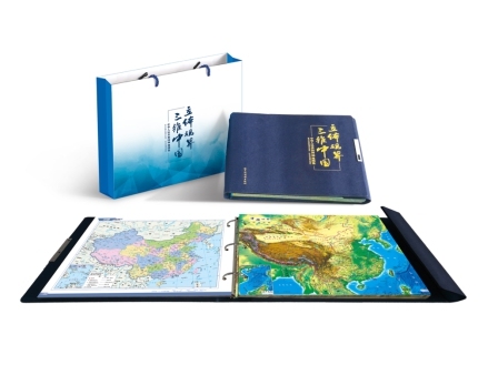
The first 3D atlas of China has been published by Harbin Cartographic Publishing House, the Science and Technology Daily reported on Wednesday.
The publisher has used a unique optical grating material to print some of the map images. The result is that the maps have a 3D appearance when looked at with the naked eye. The atlas provides data on transportation systems, tourists sites, and historical areas around China.


- Foreign delegates tour Yangtze restoration in Hubei's Yichang
- Six-year-old panda En En delivers cub in Sichuan
- Canadian father says Beijing changed his thinking on parenting, safety
- Giant panda Hua Ni gives birth to female cub in South Korea
- Shouldering cement for a living, Hunan mother sends daughter to gaokao
- Guizhou villagers sell eggs, honey through weekly livestream sales